![Item #399 [WORLD MAP] A Map of the World in Japanese by Ed. Schnell Yokohama February 1862 (Bankoku Kokaizu). Edward Schnell, Kango Takeda.](https://bookvica.cdn.bibliopolis.com/pictures/399.jpg?width=768&height=1000&fit=bounds&auto=webp&v=1519383617)
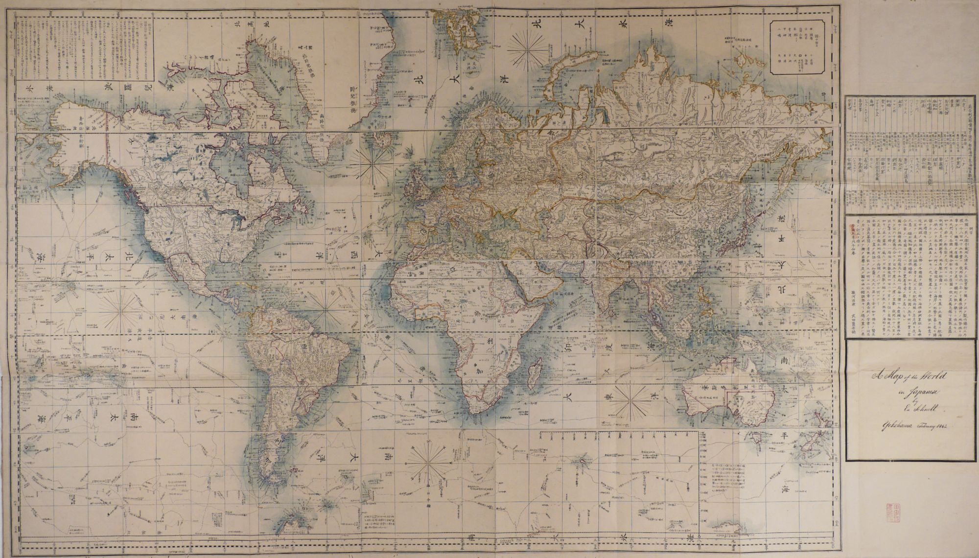
[WORLD MAP] A Map of the World in Japanese by Ed. Schnell Yokohama February 1862 (Bankoku Kokaizu)
Yokohama: 1862. Item #399
Original outline hand coloured copper engraved map. 88x156 cm. Folding map in original beige linen covers with printed pink paper title label on front cover. Some minor worming of blank margins, but overall a very good copy in very original condition.
Rare map with only three copies found in Worldcat. This large format map published by Edward Schnell (1834-1890) is the corrected and updated second edition of the map published in 1858 by Kango Takeda, who had translated and redrawn the 1845 world map by John Purdy et al titled: ‘‘A New Chart of the World On Mercator’s Projection with the Tracks of the Most Celebrated & Recent Navigators’’. The original 1845 map had been owned and used by Admiral Yevfimy Putyatin on his ship Diana during his diplomatic mission to Japan which resulted in the signing of the Treaty of Shimoda in 1855. However, the Diana sank in the Bay of Miyajima-mura after the powerful Ansei-Tōkai earthquake of 23 December 1854. Nevertheless, Putyatin’s world map was saved and came into the hands of Kango Takeda, who translated it and produced a Japanese version of it in 1858. Then in 1862 Edward
Schnell updated and corrected Takeda’s 1858 map and published the present map. This world map on Mercator’s projection, has several text boxes including a distance chart with distances from London shown to various destinations and a chronological list of the most important explorers. The routes of the voyages of major 18th and 19th century explorers such as Captain Cook’s et al are also shown on the map.
‘‘The publisher, Edward Schnell, was a Dutch-German arms dealer who lived in Japan in the 1860s. This was a period when Japan was gradually lifting restrictions on foreigners, encouraging trade and opening communication with the west. This map is one of the first Japanese maps to be based on the Mercator projection’’ (sl.nsw.gov.au). Edward Schnell ‘‘also served the Aizu domain as a military instructor and procurer of weapons’’ (Wikipedia). Edward Schnell, who in the 1850s had served in the Prussian Army and spoke Malay, traveled to Japan in around 1860 following the enforced opening of Yokohama to foreign trade.
Sold