![Item #598 [FIRST ILLUSTRATED RUSSIAN PLAN OF MOSCOW AND THE MOSCOW REGION] Plan Tsartsvuyushchego Grada Moskvy s Pokazaniyem Lezhashchikh Miest na Tridtsat Verst v Okruge [i.e. A Plan of the Reigning City of Moscow, with the Indication of the Nearby Places for Thirty Versts]. M. I. Makhayev, P. T. Balabin, J. Trusscott, artist, engraver, cartographer.](https://bookvica.cdn.bibliopolis.com/pictures/598.jpg?width=768&height=1000&fit=bounds&auto=webp&v=1549627054)
![[FIRST ILLUSTRATED RUSSIAN PLAN OF MOSCOW AND THE MOSCOW REGION] Plan Tsartsvuyushchego Grada Moskvy s Pokazaniyem Lezhashchikh Miest na Tridtsat Verst v Okruge [i.e. A Plan of the Reigning City of Moscow, with the Indication of the Nearby Places for Thirty Versts]](https://bookvica.cdn.bibliopolis.com/pictures/598_2.jpg?auto=webp&v=1549627190)
[FIRST ILLUSTRATED RUSSIAN PLAN OF MOSCOW AND THE MOSCOW REGION] Plan Tsartsvuyushchego Grada Moskvy s Pokazaniyem Lezhashchikh Miest na Tridtsat Verst v Okruge [i.e. A Plan of the Reigning City of Moscow, with the Indication of the Nearby Places for Thirty Versts]
Item #598
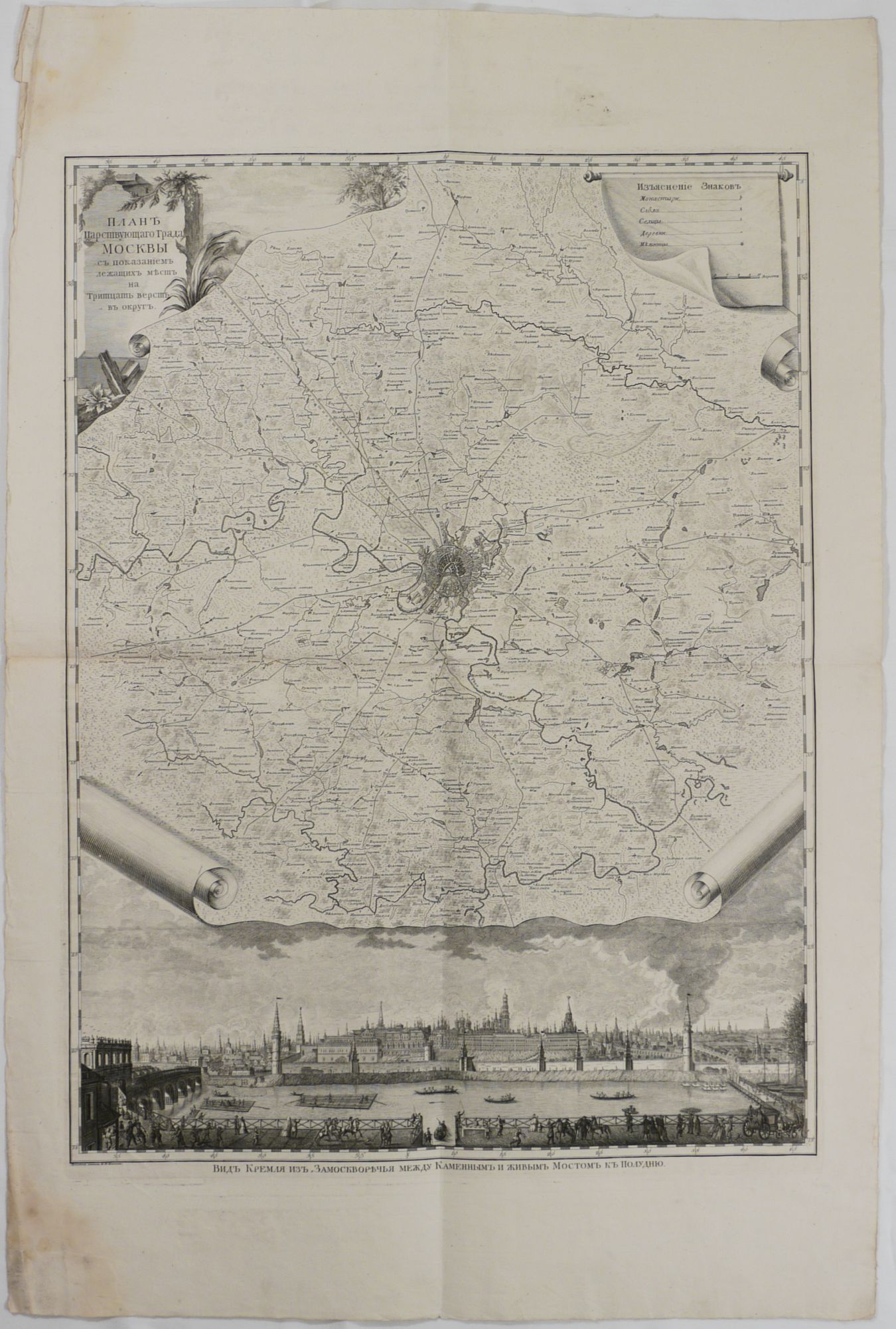
[Illustrated with:] Vid Kremlya iz Zamoskvorechya mezhdu Kamennym i Zhivym Mostom k Poludnyu [A View of the Kremlin from Zamoskvorechye between the Stone and Alive Bridge in the South]. [St. Petersburg: Academy of Sciences, 1763-1766]. Large copper engraved plan, ca. 77,5x57 cm. The engraved area houses the title and the map legend placed within copper engraved cartouches in the upper left and upper right corners, and a copper engraved panorama of the Moscow Kremlin on the bottom. Artist’s name and the title to the panorama placed under the image. Overall a strong impression with wide margins.
One of the earliest Russian plans of Moscow, and the first one combining the plan of the city with the map of the surrounding area and a panoramic view of Moscow, in this case showing the Kremlin. The plan of Moscow is placed in the centre and shows the city within the borders of the Kamer-Kollezhsky Rampart (the third historical ring of Moscow, built in 1731-42, by 1806 became Moscow’s police border), but not outlining the rampart itself. The plan is based on the first geodesic plan of Moscow compiled in 1739 by the team of surveyors under the leadership of Moscow architect Ivan Michurin (1700-1763). The map shows the area of “thirty versts” (about 50 km) outside the Kamer-Kollezhsky Rampart, thus covering the territory of the whole modern-day Moscow (within the borders of Moscow Automobile Ring Road) and Moscow Metropolitan area or Greater Moscow roughly within the first rural ring (Moscow Maloye Koltso or road A107). Highly detailed, the map marks all settlements, private estates, monasteries and churches, windmills, rivers and their tributaries, and main roads leading from Moscow to different parts of Russia (now major city “shosses” or highways,). Many of the villages and private estates shown on the map have been demolished during Moscow’s growth during the next 150 years, like Troitskoye estate of Darya Saltykova (1730- 1801), a rich noblewoman and an infamous mass murderer of her serfs (modern-day Mosrentgen settlement south of the Tyoply Stan district of Moscow). Some estates became famous Russian museums, like Kuskovo of Count Sheremetyev (Veshnyaki district in the east of Moscow), or Arkhangelskoye of Prince Boris Yusupov (near Krasnogorsk, north of Moscow). West of the city border is shown the Zvenigorodskaya road - the predecessor of the modern-day Rublyovo-Uspenskoye highway, the area where live modern Russia’s “rich and beautiful.” The lands around the Zvenigorodskaya road has become the site of Russian elite’s residences since the times of Ivan the Terrible, and the road itself had a nickname of “tsar’s road.” The map shows several villages and settlements in the area of modern-day “Rublyovka,” including Razdory, royal estate Usovo (president Putin’s residence Novo-Ogaryovo is located nearby), Znamenskoye, Dubtsy, Spasskoye etc.
The panorama of Moscow drawn by Mkhail Makhayev repeats the composition of the famous monumental “View of Moscow from Zamoskvorechye” engraved by Pieter Picart (1707), with the omission of the right part. The view shows the Kremlin and Moscow River from the south, between Bolshoy Kamenny Bridge and so-called “Zhivoy” (“alive” or removable) wooden bridge on the site of the modern-day Bolshoy Moskvoretsky Bridge; with boats and rafts on the river, and lively scenes with carriages, horses and passers-by on the Zamoskvorechye embankment in the foreground. The title and the map legend are placed in cartouches decorated with tree branches, reeds and leaves; the corners of the map area are finished with decorative rolls – which refers to Mikhail Makhayev who used the same detail in the drawings for the coronation album of Catherine II in 1762-63. This view was based on the picture projected by a camera obscura which was then outlined by Makhayev in pencil on a leaf of paper; this allowed some modern bibliographers to call Makhayev’s view “the first photography of the Moscow Kremlin” (Moskva na starykh kartakh..., No. 27).
The map is often called the “Lomonosov’s plan of Moscow” asit was published under the supervision of a prominent Russian scientistand writer Mikhail Lomonosov, then the head of the Geographical Department of the Imperial Academy of Sciences.
Moskva na starykh kartakh... [Moscow on the old maps], No. 27; Klepikov, S. Bibliografia pechatnykh planov goroda Moskvy XVI-XIX vekov [Bibliography of printed plans of Moscow, 16-19 centuries]. No. 60; Bokachyov, N. Geograficheskiye karty Rossii XV-XIX stoletiya [Geographic Maps of Russia of 15-19 centuries]. No. 329.
Sold