![Item #1070 [ONE OF THE FIRST MAPS OF THE SOVIET SOCIALIST REPUBLIC OF GEORGIA] Sakartvelos sabch’ota sotsialist’uri resp’ublik’is p’olit’ik’ur-ek’onomiuri ruk’a / shedgenili da shemushavebuli sak. geograpiuli sazogadoebis k’art’ograpiul inst’it’ut’shi p’rop. al. javakhishvilis da asist’. s. tskhak’aias khelmdzghvanelobit [i.e. Political and Economic Map of the Georgian SSR / Compiled at the Cartographic Institute of the Geographical Society of Georgia under the Leadership of Professor Alexander Javakhishvili and Assistant Sergi Tskhakaia]](https://bookvica.cdn.bibliopolis.com/pictures/1070.jpg?width=768&height=1000&fit=bounds&auto=webp&v=1601556323)
![[ONE OF THE FIRST MAPS OF THE SOVIET SOCIALIST REPUBLIC OF GEORGIA] Sakartvelos sabch’ota sotsialist’uri resp’ublik’is p’olit’ik’ur-ek’onomiuri ruk’a / shedgenili da shemushavebuli sak. geograpiuli sazogadoebis k’art’ograpiul inst’it’ut’shi p’rop. al. javakhishvilis da asist’. s. tskhak’aias khelmdzghvanelobit [i.e. Political and Economic Map of the Georgian SSR / Compiled at the Cartographic Institute of the Geographical Society of Georgia under the Leadership of Professor Alexander Javakhishvili and Assistant Sergi Tskhakaia]](https://bookvica.cdn.bibliopolis.com/pictures/1070_2.jpg?auto=webp&v=1601556323)
[ONE OF THE FIRST MAPS OF THE SOVIET SOCIALIST REPUBLIC OF GEORGIA] Sakartvelos sabch’ota sotsialist’uri resp’ublik’is p’olit’ik’ur-ek’onomiuri ruk’a / shedgenili da shemushavebuli sak. geograpiuli sazogadoebis k’art’ograpiul inst’it’ut’shi p’rop. al. javakhishvilis da asist’. s. tskhak’aias khelmdzghvanelobit [i.e. Political and Economic Map of the Georgian SSR / Compiled at the Cartographic Institute of the Geographical Society of Georgia under the Leadership of Professor Alexander Javakhishvili and Assistant Sergi Tskhakaia]
Item #1070
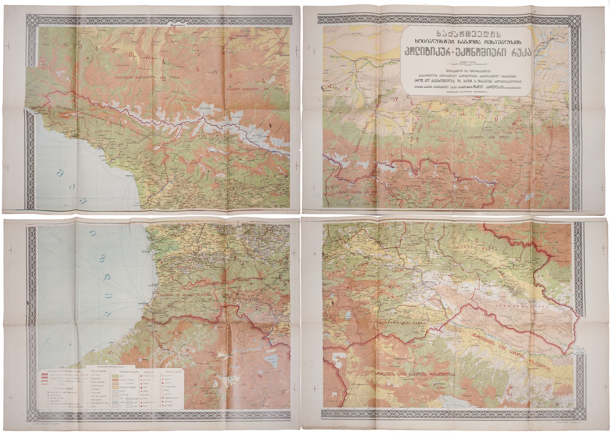
[Tbilisi]: sakartvelos sakhelmts’ipo gamomtsemloba, [ts’.a.] (sak. smus p’ol. t’r. litogr.), [1927]. Large color lithographed map ca. 114x160 cm. In 4 parts. Scale: 1:400 000. The stamps of 1930s institute that ceased to exist after WWII on the verso. Minor tears, otherwise very good.
Very rare. One of 5000 copies. AN EXTREMELY RARE ILLUSTRATIVE EVIDENCE OF POLITICAL AND ECONOMIC STATE IN THE LATE-1920S GEORGIAN SSR.
This political and economic map of the Soviet Socialist Republic of Georgia was produced by the Cartographic Institute of the Geographical Society of the Georgian SSR (by the order of its chairman Davit Kandelaki) in 1927. The piece came out a year after the establishment of the Institute and is likely to be the first-ever political and economic map of the country that was printed in Georgian.
The map fully displays the territory of the Georgian SSR by 1927 and shows Adjar Autonomous Soviet Socialist Republic, Socialist Soviet Republic of Abkhazia (both established after the Red Army invasion of Georgia in 1921), uyezds of Ananuri, Akhalkalaki, Borchalo, Gori, Dusheti, Tbilisi, Telavi, Zemo Svaneti, Lechkhumi, Sighnaghi, etc. This is particularly important considering that following the Soviet administrative reform of 1923-1929 all of the uyezds were transformed into raions, causing major changes in the administrative division of the republic. The map also indicates the borders of the country with Turkey and the Republic of Armenia in the south, the Republic of Azerbaijan in the southeast, and the Russian SSR in the north. Colors and shading are used to show the different agricultural regions in the country: pasturage (summer/winter), forested regions, and areas of grain production. Symbols indicate areas of specialized cultivation (including a great variety of corps: tobacco, tea, nuts, bay laurels, silk, and others), areas of mining for minerals (manganese, copper, iron, coal, silver, barite, etc.), resorts and areas with mineral springs. The map is densely annotated and marks villages, dabas (small cities), rivers, railroads, highways, cart roads, sea routes, ports, etc. The legend explaining all the symbols is presented in the lower left part of the map.
The map was produced under the leadership of the founders of the Georgian cartography, Alexander Javakhishvili (1875-1973) and Sergi Tskhakaia (1880-1966). The former founded the Geographical Society of the Georgian SSR (1924-1973) and managed its work further, as a vice chairman (1924-1940), chairman (1940-1969) and honorable chairman from 1970 until the last days of his life. In the mid-1920s, Javakhishvili initiated the establishment of the Cartographic Institute, which existed until 1932. Producing dozens of maps and publishing numerous theoretical works on geodesy, cartography, and topography, Javakhishvili and Tskhakaia left an indelible mark on the development of the science of geography in Georgia.
Overall, a rare survival of the time capturing the late-1920s Georgian SSR.
No copies found in Worldcat.
Sold