![Item #311 [FAR EAST] Puteshestviye v Ussuriyskom Kraye, 1867-1869 gg. S kartoy Ussuriyskogo Kraya [i.e. Travels in the Ussuri Region, 1867-1869, with a Map of the Ussuri Region, by N. Przhevalsky, Member of the Imperial Russian Geographical Society]. N. M Przhevalsky.](https://bookvica.cdn.bibliopolis.com/pictures/311.jpg?width=768&height=1000&fit=bounds&auto=webp&v=1505819038)
![[FAR EAST] Puteshestviye v Ussuriyskom Kraye, 1867-1869 gg. S kartoy Ussuriyskogo Kraya [i.e. Travels in the Ussuri Region, 1867-1869, with a Map of the Ussuri Region, by N. Przhevalsky, Member of the Imperial Russian Geographical Society]](https://bookvica.cdn.bibliopolis.com/pictures/311_2.jpg?auto=webp&v=1505819052)
![[FAR EAST] Puteshestviye v Ussuriyskom Kraye, 1867-1869 gg. S kartoy Ussuriyskogo Kraya [i.e. Travels in the Ussuri Region, 1867-1869, with a Map of the Ussuri Region, by N. Przhevalsky, Member of the Imperial Russian Geographical Society]](https://bookvica.cdn.bibliopolis.com/pictures/311_3.jpg?auto=webp&v=1505819052)
[FAR EAST] Puteshestviye v Ussuriyskom Kraye, 1867-1869 gg. S kartoy Ussuriyskogo Kraya [i.e. Travels in the Ussuri Region, 1867-1869, with a Map of the Ussuri Region, by N. Przhevalsky, Member of the Imperial Russian Geographical Society]
St. Petersburg: Izdaniye avtora, 1870. Item #311
[4], ii, iii, 297, [2], 58, [1] pp. Octavo. With a folding chromolithographed map at rear. Modern (period style) half calf with marbled papered boards; spine with raised bands and gilt lettered title. Margins slightly cut, otherwise a very good copy.
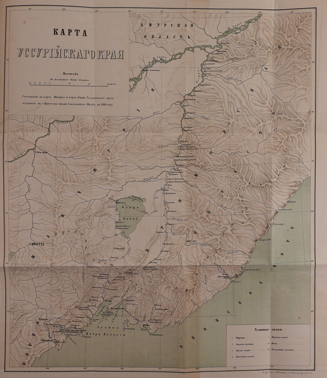
First edition of the first book by major explorer of Central Asia Nikolay Przhevalsky (1839-1888), an account of his first travel to the little known Ussuri krai in the Russian Far East annexed to the Russian Empire in 1858 with the signing of the Treaty of Aigun. In 1867-1869 Przhevalsky went up the Ussuri River from Khabarovka, followed its tributary Songacha River up to Lake Khanka, surveyed its western and southern shores, and went down the Suifen River to fort Novgorodsky, the southernmost settlement in the Ussuri region (Posyet Bay of the Japanese Sea). He then went on a strenuous journey north to St. Olga Bay not by steamer as it was common, but along the shore of the Sea of Japan, following less penetrable forest paths, and visiting Vladivostok (then a village with no more than 500 people) and Nakhodka among others. From St. Olga Bay Przhevalsky went by land to the mouth of the Tadusha (Zerkalnaya) River, crossed the Sikhote-Alin mountain range, and returned to the Ussuri River following her tributaries Fudjin (Pavlovka) and Ulukhe. In 1868 he conducted more surveys of Lake Khanka and assisted in suppression of Chinese gangs robbing Russian villages on the Suchan River.
Przhevalsky compiled the first comprehensive description of the Ussuri region, clarified the shape and geographical position of Lake Khanka, performed topographical survey of the area between Nakhodka and Tadusha River, and mapped the eastern slopes of the Sikhote-Alin mountain range. He discovered a new mammal species (black hare) and castor aralia tree (Kalopanax septemlobus). The book contains a detailed descriptions of the Ussuri region’s geography, climate, fauna and flora, life and occupations of native inhabitants and Russian settlers, agriculture, industries and trade. The map shows the Ussuri region up to the Chinese and Korean borders, outlining Przhevalsky’s route and marking main cities, Russian, Cossack and Chinese villages, military posts, and telegraph stations.
Sold